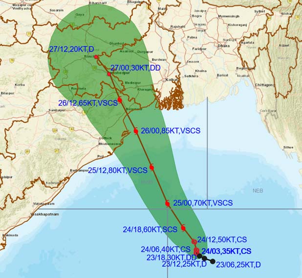
Bhubaneswar: Very Severe Cyclonic Storm ‘YAAS’ is likely to make landfall between North Of Dhamra and South of Balasore on early morning 26 May.
YAAS over Eastcentral & adjoining Westcentral Bay of Bengal moved northwestwards with a speed of about 17 kmph during past 6 hours, and lay centred at 0830 hrs IST of today over Westcentral and adjoining Eastcentral & north Bay of Bengal near latitude 18.3°N and longitude 88.3°E, about 280 km south-southeast of Paradip (Odisha), 380 km south-southeast of Balasore (Odisha), 370 km south-southeast of Digha (West Bengal) and 370 kms south-southwest of Sagar Islands (West Bengal).
It is very likely to move north-northwestwards, intensify further into a very severe cyclonic storm during next 12 hours.
It would continue to move north-northwestwards, intensify further and reach Northwest Bay of Bengal near north Odisha and West Bengal coasts very close to Chandbali-Dhamra port by the early morning of Wednesday, the 26 May. It is very likely to cross north Odisha-West Bengal coasts between Paradip and Sagar Island close to north of Dhamra and south of Balasore, during noon of Wednesday, the 26th May as a Very Severe Cyclonic Storm.
Light to moderate rainfall at many places with heavy to very heavy rainfall and extremely heavy rainfall in Jagatsinghpur, Kendrapara, Bhadrak, Balasore districts, heavy to very heavy rainfall over Puri, Khurda, Cuttack, Jajpur, Mayurbhanj and heavy over Ganjam, Dhenkanal, Keonjhargarh districts on 25th, heavy to very heavy rains at a few places with extremely heavy falls at isolated places in Jagatsinghpur, Kendrapara, Jajpur, Bhadrak, Balasore, Mayurbhanj, Cuttack, Dhenkanal, Keonjhargarh and heavy falls at isolated places in Puri, Khurda, Angul, Deogarh, Sundergarh on 26 May and heavy falls at isolated places in north interior Odisha on 27 May


