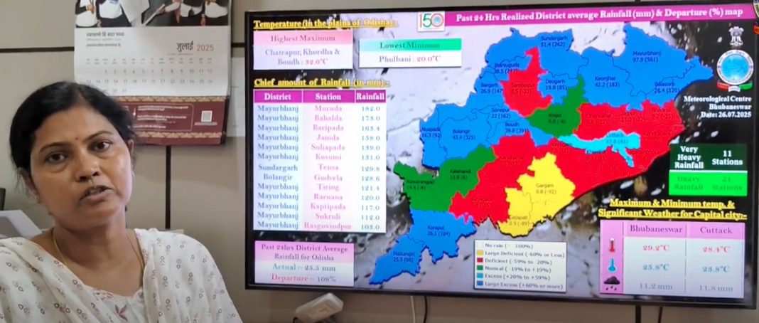
Bhubaneswar: Odisha is currently grappling with widespread heavy rainfall as a depression, originating in the Bay of Bengal, continues its west-northwestward trajectory across the state. The India Meteorological Department (IMD) has issued critical warnings, including a red alert for specific districts, prompting immediate precautionary measures. IMD Director Dr,Manorama Mohanty has issued warning.
The depression, which previously centered over coastal West Bengal and adjacent areas, is now actively influencing weather patterns across Gangetic West Bengal, northern Odisha, and Jharkhand.
Red Alert (Extremely Heavy Rainfall): Mayurbhanj and Keonjhar districts are under a red warning, signifying the likelihood of extremely heavy rain and thunderstorms, accompanied by gusty winds of 40-50 kmph. In response to the severe forecast, the Mayurbhanj administration has declared all schools closed for Saturday.
Orange Alert (Heavy to Very Heavy Rainfall): Jharsuguda, Sambalpur, Sundargarh, Balasore, Bhadrak, Jajpur, Kendrapara, Angul, Dhenkanal, and Deogarh districts are facing an orange warning, with expectations of heavy to very heavy rainfall, thunderstorms, and strong winds.
Yellow Alert (Heavy Rainfall): A yellow alert for heavy rainfall has been issued for numerous other districts, including Cuttack, Dhenkanal, Kendrapada, Jagatsinghpur, Khurda, Nayagarh, Boudh, Sonepur, Kandhamal, Bolangir, Bargarh, Malkangiri, Koraput, Nuapada, and Kalahandi.
The relentless downpour is projected to persist for at least two more days, with a potential reduction in intensity after July 28th. However, general rainfall is anticipated to continue until July 30th due to renewed monsoon flow.
In the past 24 hours, Baripada and Kotpad recorded the highest rainfall in Odisha, each receiving 130mm. Jharigaon in Nabarangpur district also reported a significant 131.4 mm of rainfall.
The heavy rains have already led to waterlogging in urban areas, causing damage to temporary structures and roads, and disrupting power and communication lines in certain parts of the state.
Of particular concern is the Jalaka River in Balasore, which has breached its danger level at Mathani, flowing at 7.20 meters against a danger mark of 6.50 meters, raising immediate flood concerns for downstream regions. Similarly, the Baitarani River at Anandpur has exceeded its danger mark, and the Subarnarekha River is also showing rising trends. Twenty sluice gates of the Hirakud dam have been opened to manage floodwaters, with authorities prepared to open more if necessary.
The IMD has strictly advised fishermen to avoid venturing into the sea along and off the North and Central Bay of Bengal and West Bengal-Odisha coasts until July 29th, as sea conditions are expected to remain rough to very rough with squally winds gusting up to 60 kmph.
State authorities have urged residents in vulnerable areas to prioritize safety by staying indoors during intense rainfall, preparing emergency kits, and avoiding attempts to cross overflowing rivers or streams. Continuous monitoring of official weather alerts from IMD and local authorities is crucial. Disaster response protocols across the state have been activated to address any emerging situations.
Despite the immediate challenges posed by the heavy rainfall, the state’s overall rainfall deficit since the beginning of June has improved to 17%, with only a handful of districts still reporting a deficit.


