

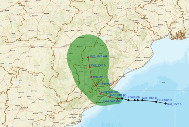
Bhubaneswar: A deep depression centered over the west-central and adjoining northwest Bay of Bengal is set to make landfall along the north Andhra Pradesh and south Odisha coasts between Visakhapatnam and Gopalpur, near Kalingapatnam, by the night of September 23, 2026. According to a special bulletin issued by the India Meteorological Department Meteorological Centre in Bhubaneswar, the system was centered approximately 70 km east-southeast of Kalingapatnam and 150 km south of Gopalpur as of 0530 IST on September 23. Moving west-northwestward at a speed of 12 kmph, the deep depression carries maximum sustained surface wind speeds of 55 to 65 kmph, with gusts reaching up to 75 kmph.
Heavy rainfall has already been recorded across southern and coastal districts of Odisha in the 24 hours leading up to September 23 morning. Similiguda in Koraput district received the highest precipitation at 23 cm, followed by Jeypore at 16 cm, Berhampur at 15 cm, Borigumma and Tentulikhunti at 14 cm each, and Balasore and Nandahandi at 13 cm. Other areas including Gopalpur, Remuna, and R. Udayagiri logged 10 cm of rainfall.
The India Meteorological Department has issued sequential weather warnings for the state through September 27. A red warning for heavy to very heavy rainfall with isolated extremely heavy rain is active until 0830 IST on September 24 for Koraput, Malkangiri, Kalahandi, and Nawarangpur districts. An orange warning covers Nuapada, Balangir, Kandhamal, Rayagada, Gajapati, Ganjam, Puri, Khordha, Nayagarh, Boudh, Sonepur, and Bargarh during the same period. For September 24 to 25, a red warning remains in effect for Nawarangpur, while orange warnings persist over several western and southern districts including Bargarh, Nuapada, Balangir, Kalahandi, Koraput, and Malkangiri. A flash flood risk warning has also been highlighted for low-lying areas and watersheds across southern and central Odisha districts due to expected runoff and saturated soils.
Coastal and maritime conditions are projected to remain severe. Squally wind speeds of 55 to 65 kmph gusting to 75 kmph will prevail along off south Odisha and north Andhra Pradesh coasts until the evening of September 24 before gradually subsiding. Sea conditions are rated very rough over the westcentral and northwest Bay of Bengal. In response, Local Cautionary Signal Number Three (LC-3) has been hoisted at all ports in Odisha. Fishermen have been strictly advised not to venture into the Bay of Bengal or along the Odisha, Andhra Pradesh, and West Bengal coasts through September 24.
The official advisory outlines potential impacts, including localized flooding, waterlogging on urban roads, minor damage to power lines and unreinforced structures, uprooting of tree branches, and disruptions to rail, road, and offshore operations. Residents in vulnerable areas are advised to stay indoors, close doors and windows, unplug electronic devices, avoid shelter under trees or near water bodies, and verify traffic conditions prior to travelling.