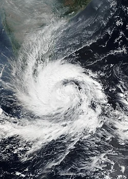
Bhubaneswar: While Cyclonic Storm Ditwah continues to pose a significant threat to the coasts of Tamil Nadu, Puducherry, and South Andhra Pradesh, Odisha is expected to escape any major direct impact from the severe weather system.
The India Meteorological Department (IMD) forecasts indicate that the cyclonic storm is tracking north-northwestwards, largely parallel to the South Indian coast. The system is currently focused on bringing heavy to extremely heavy rainfall and strong gale-force winds to the northern coastal regions of Tamil Nadu and the adjoining districts of South Coastal Andhra Pradesh.
For Odisha, the forecast remains relatively stable. No severe weather warning has been issued, and the state is expected to experience only marginal effects, primarily due to the distance of the system’s trajectory. Rainfall activity, if any, will be isolated and light, mostly confined to the southern districts bordering Andhra Pradesh.
The main concern for Odisha is limited to sea conditions. Fishermen have been strictly advised not to venture into the deep sea areas of the Westcentral Bay of Bengal adjoining the Andhra Pradesh coast till at least December 1 as sea conditions will be rough to very rough. Coastal authorities in districts like Ganjam, Gajapati, and Puri are monitoring the situation as a precaution, but no alerts for heavy rainfall or high winds have been raised.
The cyclonic storm Ditwah is expected to weaken into a deep depression by Monday, December 1, after moving close to the North Tamil Nadu and Puducherry coast, further reducing any potential threat to the Odisha coast. State disaster response forces remain on standby as a standard protocol for any Bay of Bengal system but are currently focused on providing support to the southern states if required.


